Walking Buckingham to Milton Keynes

Walking Buckingham to Milton Keynes
As walks start, it felt like this wasn’t going to be too much of a tricky walk, starting out in a housing estate on the edge of Buckingham, I was quickly beside the river Ouse, as it winds its way through the town, but it wasn’t very long before the route I was walking, The Ouse Valley Way, detoured away from the rivers edge and headed out of tow towards the old, disused, but being restored, Buckingham arm of the Grand Union Canal.
 |
| Ouse in Buckingham |
 |
| Route Sign Post |
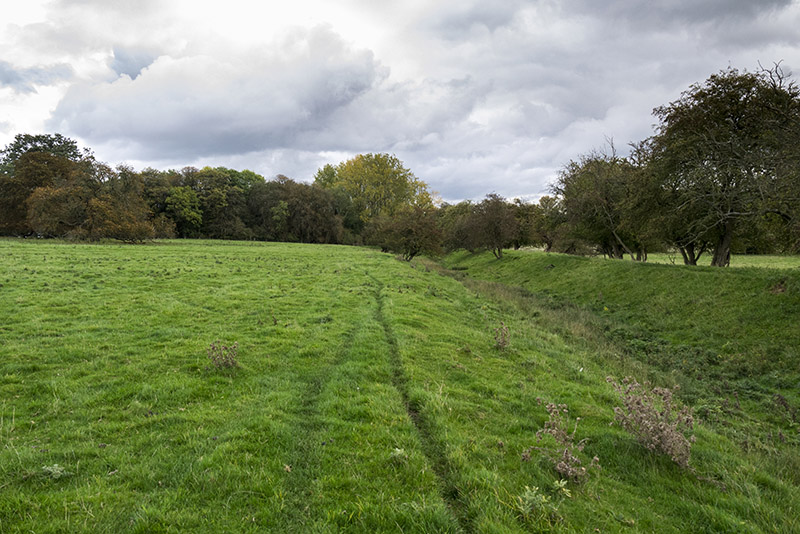
Bourton Meadow
After crossing the A413 the canal restoration project becomes noticeable, as a small stretch of canal now has a tow path, and is filled with murky water and thriving plants, it will be a nice easy walk once fully complete, but after on a few hundred yards the towpath is don, along with the current restored canal and you find yourself striding off across country.
 |
| Restored section of Buckingham Arm of Grand Union Canal |
 |
| Reed heads |
After leaving the restored canal, the Ouse becomes your accompanying companion once more, although all too briefly, as the path picks up the old canal route again, leaving the river to its slow winding course across the fields.
 |
| River Ouse |
 |
| Views of Buckinghamshire over Maize Fields |
Buckingham Canal Nature Reserve
Leaving the tall crops behind, I found myself in an area I used to know as Hyde Lane nature reserve (BBOWT), this is now leased from the wildlife trust by the Buckingham Canal trust and called the Buckingham Canal Nature Reserve. The large lake of the reserve stretches beyond the old canal and through newly restored hedges, and could well be a distraction on another day.
The path of the Ouse Valley Way once again follows semi restored canal (no water), this time along leaf enshrouded paths, through a multitude of trees, before eventually passing a restored lock, with a small seating area.
 |
| Leaf Shrouded Paths of Buckingham Canal Nature Reserve |
 at Buckingham Canal Nature Reserve") |
| Restored lock (very narrow) at Buckingham Canal Nature Reserve |
As the nature reserve ends the path becomes unmarked and runs through clumps of nettles and fallen trees, it could really do with a clean up, and I have informed Buckinghamshire Council of the need for this.
 |
| Ouse Valley Way continues through Nettles |
 |
| Ouse Valley Way |
Cross Country to Beachampton
The section of the Ouse Valley Way from the Buckingham Canal nature reserve to Beachampton is where the route became… interesting!
At first, continuing to follow the abandoned canal, the route is very green, lots of open, grassy fields with not much about, the odd house (usually in decay), or farm building, a few sheep or cattle feasting on the lush grass etc. but occasionally things became interesting for various reasons.
 |
| Desolate fields |
Blocked Paths
The first instance of this is through a set of farm buildings, where the path is pretty much impassable! I had to scramble along the precarious, dilapidated, fence, in order to avoid having to hack my way through thick brambles! (again I have reported this to Buckinghamshire Council).
 |
| Spot the path! it is meant to run between the fence and the post! |
Then, after more relaxed, walking through the lush grassy, sheep and cattle fields of Buckinghamshire country side, just after the route passes the boarding school of Thornton Collage, the route takes a very off road track, the path passing through the middle of crop fields, which, in my case, were quite recently ploughed. Now I don’t know how often you will have walked recently ploughed fields but they are VERY uneven and a real strain to walk over, so passing a couple of large ones really took their toll.
And then there were the cows!
After struggling my way through the muddy, ploughed fields, I reached a large field containing a gang of the ferocious beasts. As I began to gingerly make my way across their territory, the smaller bullocks in the group began to stir, at first scattering away in front of me, but slowly becoming accustomed to a stranger in their mix, the curiosity took over and they all stopped to stare, then the larger bullocks began to front it, and move towards me. I could see a glint in their eyes as they recognised a tasty meal in me.
All of a sudden they began to come at me with purpose. Knives drawn I could almost taste the blood lust in the air. I turned and quickly began to hurry my way back to the safety of a metal gate, the rabid beasts close on my tale, hot air being snorted from their angry, carnivorous faces.
Safety
Eventually they tired of the pursuit and returned to the peaceful, grazing animals that others see them as. And I was able to cautiously make my way around the edge of the field, avoiding the gaze of their hungry eyes, before leaping fences and gaining the safe haven of an enclosed field, where I could get back on track once more, arriving in Beachampton just after 1 in the afternoon.
 |
| Church at Beachampton |
Onward to Lower Weald
I paused for a bite to eat, resting on a style just outside of Beachampton, the views, over my shoulder, of the small hamlet, were beautiful, even in the dull autumn weather and it seemed a perfect spot. After a change of t-shirt and a few painkillers and I was once again ready to walk on. And the path ahead of me was pretty easy. A well marked footpath across the fields made life simple as I strolled. Above me Skylark and pipits buzzed through the air, large Buzzards and fork tailed Red Kite soared on stiff wings, riding the strong winds with ease, and the grey clouds whipped across the skies.
 |
| Views back across fields to Beachampton |
Seeing MK
It wasn’t long till I was once again on the edges of Milton Keynes, the walk between having had no real incidents or notes (I did skirt on field via the road rather than staying inside due to warnings of a bull, but it didn’t alter the route much, I was over the other side of the hedge is all). The path of the Ouse Valley Way meeting up with the Milton Keynes Boundary walk from here on in.
And then all of a sudden I realised I was by the tennis courts of Calverton Place and I realised I was now retracing the steps I had taken earlier in the year, in February to be precise, on my North West MK circular walk. It was here that I nearly trod on a levert, the young of a hare, hunkered low in the grass, I hadn’t realised it was an animal until it moved as my footstep landed next to it.
 |
| Tennis Courts |
 |
| Leveret |
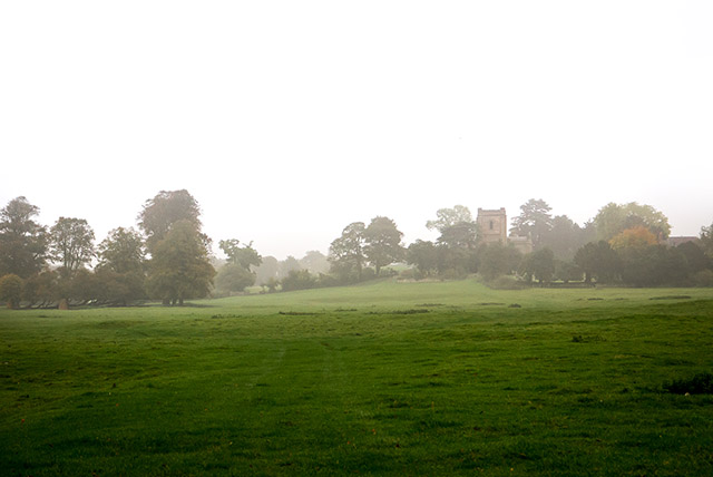
The farm and church buildings of Lower Weald appeared from behind the trees to my right as I crossed the fields finally meeting back up with the river Ouse as it entered Stony Stratford.
 |
| Church at Lowe Weald |
 |
| Dark Skies over Lower Weald |
Stony Stratford to the Iron Trunk
Back on home grounds I quickly walked the stretch of river from Stony Stratford all the way to the Iron Trunk Aqueduct. Before finally heading back along the canal to Old Wolverton, where this walk ended. Well the mapped route, I of course walked home from here.
 |
| Stony Nature Reserve River Ouse |
Buckingham to Milton Keynes Route Stats
The final walk from Buckingham to Milton Keynes was 11.73 miles. This is from the start in Buckingham, to the Galleon in Old Wolverton (I carried on home from here). Total time taken: 5 hours 3 minutes.
Now you may notice this is longer than the map below shows. Well this is because I adjusted the map to follow the real route. Correcting my odd mistake, and turning back and circling around after the cattle incident. I didn’t take many breaks along the route, apart from the change of t-shirt and sandwich; and a chat with my brother in law.
Buckingham to Milton Keynes Route Map
Other Photos
 |
| Restored Canal in Buckingham |
 |
| Sheep staring |
 |
| Views over Bourton Meadow |
 |
| Restored Lock at Buckingham Canal Nature Reserve |
 |
| Bull |
 |
| Buckinghamshire Countryside |
 |
| Fields of Maize |
 |
| Orchard near Calverton |
 |
| Lower Weald Buildings |
 |
| Lowe Weald Church |
 |
| Stony Stratford Ouse |
 |
| Old Wolverton Fields |
 |
| Wolverton Mill Fields Panorama the end of my Buckingham to Milton Keynes walk |
Linking to…

I’m Walking 2500 miles in 2017 to raise money for Birding For All – Read about it here – Please consider donating through My Donate
Did you enjoy Buckingham to Milton Keynes? or find it useful? Then please consider sharing with friends, via the links below.


6 Comments
Cherry
That was a very interesting and 'fun' walk. I don't think I would have been as brave as you with the bullocks – I know how scary they can be! But I enjoyed your narrative very much.
AshleyBeolens
Thanks mum 🙂
Potty Adventures
It sounds and looks like the restorative work that has been going on in the area is paying dividends. It looks like a lovely, peaceful place to walk and well done for resisting the corn on the cobs haha. Thanks for joining us on #adventurecalling . I hope you can again when it opens tomorrow morning.
AshleyBeolens
It will be great if/when they can fully restore the whole section of canal, opening up more areas for people to visit etc. It's always sad to think of the loss of access that we accept in the UK for the sake of progress (roads)
The Helpful Hiker
The last time we met cows I feared for my life, so I can empathise! It's so annoying when paths aren't maintained. I know it costs money but it's always a pain when you have to fight through, or even take a detour. I love your photos, even on a dull day the views are beautiful. Thank you for sharing with us at #AdventureCalling
AshleyBeolens
hank you. I think the older I get the more my fear comes out, stick me in a room with an armed man and I'd be less scared, at least I have a chance of talking my way out of that 🙂